Mapping
Orthophotos and DTM/DSM
Georeferenced orthophotos and digital terrain and surface models for survey, planning and development work.
Service · Aerial capture
We produce orthophotos, 3D models, point clouds and high-resolution textures from planned flights, survey control and photogrammetric processing built for technical use. We fly anywhere in Spain, and we hold the operator and pilot licences the Spanish authority requires.
Photogrammetry reconstructs a site or a building from overlapping photographs: the software cross-references hundreds of images taken from the drone and computes the 3D position of every detail, producing models at real scale and in real coordinates. It is the quickest way to cover large areas, roofs and hard-to-reach zones without scaffolding or road closures.
Mapping
Georeferenced orthophotos and digital terrain and surface models for survey, planning and development work.
Construction
Progress control, volume measurement and earthworks calculation from repeat flights on a fixed cycle.
Inspection
Inspection of roofs, warehouse coverings and façades with no access equipment, at high image resolution.
With a photogrammetric drone we cover up to 400 ha in a single day, at 5 cm accuracy (2–3 cm when the flight is supported with ground control points).
| Measure | Conventional surveying | Photogrammetric drone |
|---|---|---|
| Point density | 20–60 points/ha | About 9,700,000 points/ha (970 pts/m²) |
| Points captured per day | 800–1,000 | About 3.9 billion |
| Output (two-person team) | 5–20 ha/day | 400 ha/day |
| Vertical accuracy | 2–3 cm | ~5 cm (2–3 cm with GCPs) |
| Additional product | Field sketch | 3.2 cm/px orthophoto, DSM, 3D mesh, obliques |
Drone photogrammetry is faster and cheaper, and fits urban areas better, where flight permissions are simpler and there is no vegetation to see through.
Where dense vegetation has to be penetrated, or the ground has too little visual texture, the alternative is drone LIDAR: it measures with a laser rather than photographs, at a higher operating cost.
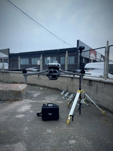
Photogrammetric flight with ground control points over an industrial warehouse. On this kind of project we combine photogrammetry with drone LIDAR where there are roofs or raised areas under vegetation, as at the Retamares water tank for Canal de Isabel II.
We process the flight and hand over technical products matched to each use, combinable with ground-based capture.
We plan the flight around resolution, coverage, survey control and what the model is finally for. Here is the whole sequence, from flight plan to 3D model.
GSD (Ground Sample Distance) is the real size of ground each pixel of the orthophoto represents: the smaller the GSD, the more detail, but the longer the flight and the processing. We choose GSD from what has to be detected, not by default.
With ground control points (GCPs) and GNSS RTK, drone photogrammetry reaches accuracies of a few centimetres — enough for topographic survey, volume measurement and technical orthophotos.
Yes. We operate with a registered operator and licensed pilots, and we obtain the authorisations from AESA — the Spanish civil aviation authority — along with any airspace clearances required, before each flight. For an overseas client this is the part of the job that most often causes delay, and we take it on as part of the service.
Georeferenced orthophotos (GeoTIFF), textured 3D models (OBJ, FBX), dense point clouds (LAS, LAZ), digital terrain and surface models (DTM/DSM) and mapping in DWG or SHP for GIS.
Up to 400 hectares in a single day, against 5–20 ha/day for a conventional two-person survey team. Density changes scale too: roughly 20–60 points/ha with conventional surveying against around 9.7 million points/ha with photogrammetry, at about 5 cm accuracy (2–3 cm when the flight is supported with ground control points).
Drone photogrammetry is faster and cheaper, and fits urban areas better, where flight permissions are simpler. Drone LIDAR is the right call where dense vegetation has to be penetrated or the ground has too little visual texture, though its operating cost is higher.
Tell us what you need surveyed. We review your case with no obligation and send back a technical and commercial proposal matched to your requirements — in English, working to your project timetable.