How a building is surveyed by drone

From drone flight
to 3D model

A drone measures the building or the plot from the air: a laser sensor takes millions of measurements while a camera takes the photographs. Out of that comes a point cloud placed in coordinates and, on top of it, the 3D model of the real state — not an interpretation of old drawings. Four phases: flight plan, capture, cloud and modelling.

Scroll

o pasa de fase con ← →

Context

What gets measured from the air

The flight reaches what is costly or invisible from the ground: roofs, internal courtyards, whole plots and long alignments. Looking at the site as a whole, we decide what has to be measured, at what detail and from what height — and that agreement governs the four phases that follow.

Phase 01 · Planning

Every survey has its flight plan

The flight plan is the route, the height and the overlap the drone will use to cover the object, and it is designed around it: built-up area, industrial warehouse, plot, linear works or roof. From that come the height, the overlap and the speed, calculated from the GSD and the point density the final use of the model requires. Before flying, the control points are set out — targets on roads and open surfaces — measured with GNSS. In urban settings the plan is also adjusted to the applicable Spanish flight authorisations.

1.2 cm/px Pixel size (GSD)
80 / 70 % Overlap between passes
70 m Flying height

Phase 02 · Site capture

Laser and camera, on the same flight

The drone flies the planned passes at constant height and speed. The LIDAR records the sweep perpendicular to the direction of travel and the camera takes the photographs at the planned overlap. Every laser shot and every photograph is referenced to the drone's trajectory, recorded with precision GNSS and IMU. The planned overlap is what guarantees that no surface is left uncovered and that every area is measured more than once.

2M pts/s Measurements per second
5 Returns per shot
45 min Endurance per flight

Phase 03 · Point cloud

The flight becomes a measurable cloud

The passes are adjusted against each other and against the control points measured on site. The result is a dense point cloud, georeferenced and classified by surface type — ground, vegetation and buildings — so that every façade, cornice and kerb exists as a measurable coordinate before a single line is drawn. The residual deviation at the control points is documented: accuracy is verified, not assumed.

1,400 pts/m² Cloud density
±2 cm Absolute accuracy
LAS · LAZ · E57 Formats

Phase 04 · Modelling and delivery

Three layers, one coordinate system

Delivery is a layered viewer: the base mapping georeferences, the cloud supplies the measurement and the modelled geometry supplies the BIM object. The three superimpose with no intermediate transformations, so any dimension in the model can be checked against the points it came from.

03
3D model · as-built BIM Defined volumes, LOD 200–300. IFC · RVT · DWG
02
Point cloud The raw measurements, exactly as they came off the flight
01
Base mapping The survey placed in coordinates

Next step

What do you need surveyed?

Tell us what has to be scanned, what the model is for and the timescale. We come back with a technical proposal: scope of the flight, achievable accuracy, deliverables and delivery date. If the project is still loose, the location and intended use are enough for us to point you in the right direction.

In short

How a drone survey works, phase by phase.

A drone survey measures a building, a plot or an item of infrastructure from the air: the LIDAR sensor and the photogrammetric camera fly a calculated flight plan and return a georeferenced point cloud to model from. The result serves to measure plots and roofs, calculate volumes, follow construction progress or produce the as-built model of a whole complex. Four linked phases. Where the survey is carried out from the ground with a fixed-station scanner the route differs: that is explained in the terrestrial scanning process.

01
Flight plan
Height, overlap and speed are calculated from the GSD and the density the use of the model demands. Control points are measured with GNSS before flying.
02
Site capture
Passes at constant height and speed with LIDAR and camera on the same flight; every shot and every photograph is referenced to the drone position.
03
Point cloud
The passes are adjusted against each other and against the control points. Out comes a dense, classified, georeferenced cloud, already measurable.
04
Modelling and delivery
A layered viewer coincident in coordinates and an as-built BIM model in IFC, RVT or DWG at the agreed LOD.
Parameters of a typical flight and output formats of a drone survey
ParameterTypical flight
Target GSD1.2 cm/px
Forward / side overlap80% / 70%
Flying height70 m
LIDAR capture rate2,000,000 points per second · 5 returns per shot
Average cloud density1,400 points/m²
Absolute accuracy±2 cm with GNSS control points
Cloud formatsLAS · LAZ · E57
Model formatsIFC · RVT · DWG · LOD 200–300

Figures for a typical flight. The real plan is calculated for each survey according to the object, the setting and the intended use of the model.

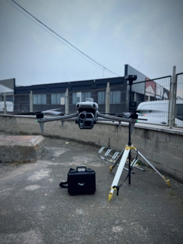
LAURIA ESCÁNER photogrammetric drone beside a ground control point target, ready to fly over an industrial warehouse
Drone and control point target before the flight
FAQ

Questions about drone surveying.

What is a drone survey for?

To measure from the air what is hard or expensive to reach from ground level: whole plots and sites, roofs, stockpile and cut volumes, long linear alignments, month-by-month construction progress and urban blocks. The flight returns a measurable point cloud and orthophoto, which design and modelling then work from.

What is GSD and why does it govern the flight?

GSD (Ground Sample Distance) is the real size of ground each pixel of the photograph represents: a GSD of 1.2 cm/px means each pixel covers 1.2 cm. Because it depends on flying height and camera, it is what fixes that height: the finer the GSD the model demands, the lower you fly and the more passes are needed.

How much overlap does a photogrammetric flight need?

As a reference, 80% forward overlap and 70% side overlap. Overlap is what guarantees that every point on the ground appears in several photographs and that no surface is left uncovered; on façades or in strong relief it is increased, and completed with oblique passes.

What accuracy does a drone survey achieve?

In the order of ±2 cm absolute accuracy at average densities around 1,400 points per square metre, provided the flight is supported by control points measured with GNSS. Without those control points the cloud can be dense and still be badly positioned.

What is the difference between drone LIDAR and drone photogrammetry?

LIDAR measures by firing a laser beam and records several returns per shot, so it sees through vegetation and recovers the ground under the canopy. Photogrammetry reconstructs geometry from overlapping photographs and brings real colour and texture, but it cannot see what the image cannot see. Flying both sensors on the same mission gives you both, in the same coordinate system.

Can you fly a drone over a built-up area in Spain?

Yes, but urban flight forces two adjustments. First the plan: the legal constraints of the area and of the operation type set the height, the route, the distance to people and buildings and the time window, so they are checked before the plan and the date are fixed. Second the equipment: sometimes the answer is a lighter drone or a different operational category, even if that means flying lower with more passes to hold the GSD. And where the air cannot reach everything, the flight is combined with SLAM scanning at street level: the drone contributes roofs and plan geometry, SLAM contributes façades, porches and interiors, and both clouds are registered together to keep the best definition from each method.

What is delivered after the flight?

The point cloud in LAS, LAZ or E57, and the derived model in IFC, RVT or DWG at the agreed level of detail, normally LOD 200–300. All georeferenced in the project coordinate system and viewable in a layered web viewer.

Seguir

From the process to the actual service.

Contact

Have a site in Spain
that needs capturing?

Tell us what you need surveyed. We review your case with no obligation and send back a technical and commercial proposal matched to your requirements — in English, working to your project timetable.

Email hola...
Coverage Spain · International clients